Name/Title
St. George River Canoe TrailEntry/Object ID
WHC 2024.15.2Scope and Content
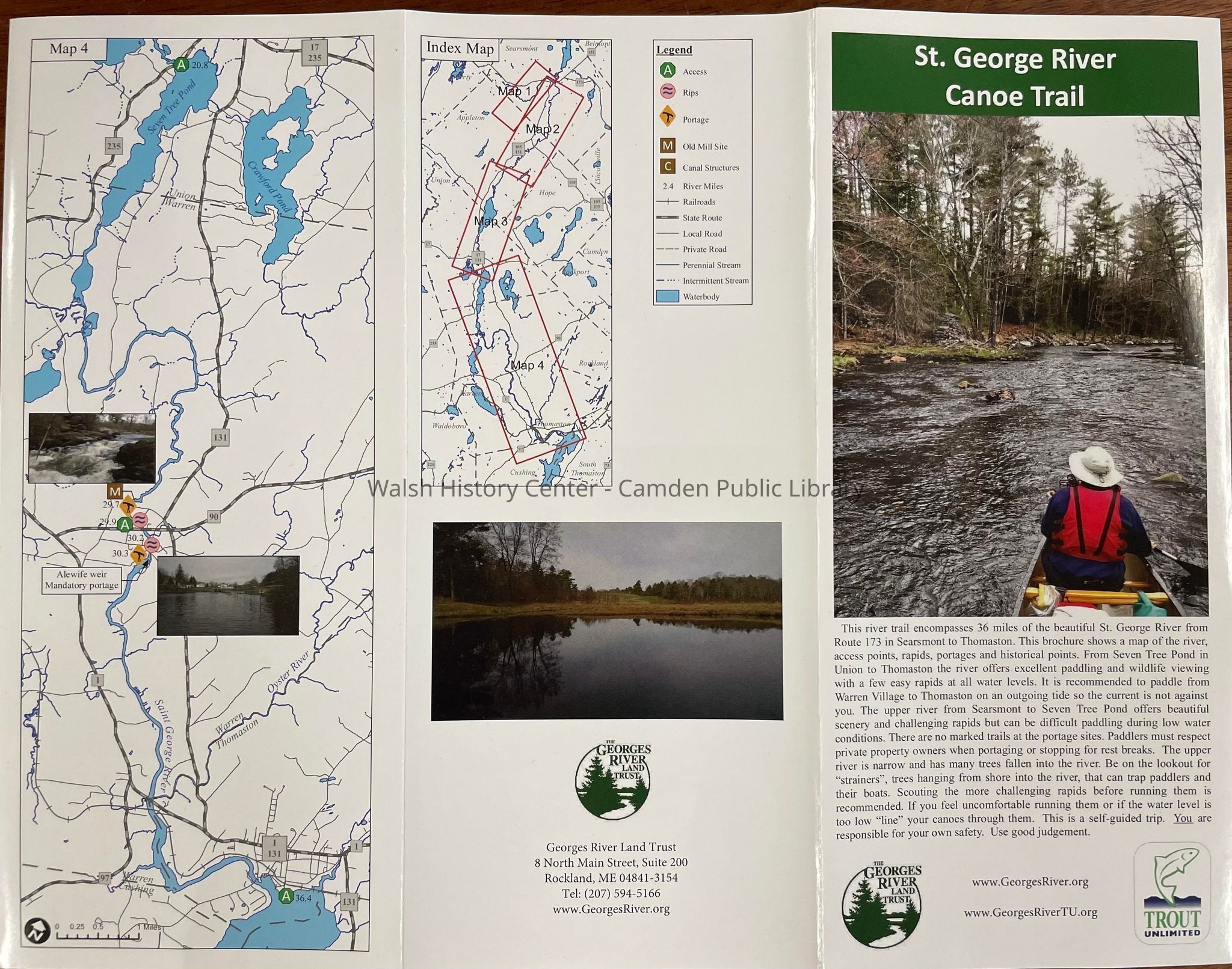
Trifold color brochure on glossy paper; double sided (6 panels).
- Panel 1. Cover: St. George River Canoe Trail" Photo of a section of that trail and George's river Trout unlimited, and the related websites.
- Panel 2: Map 1. Searsmont section and photo. Searsmont village to Ripley Corner Road.
- Panel 3: Map 2. Searsmont village to Appleton Village. Photo.
- Panel 4: Map 3. Appleton Village to Union, Round Pond. 2 photos.
- Panel 5. Map 4. Round pond in Union to the saltwater estuary of the George's River in Warren/Thomaston/Cushing. 2 photos.
- Panel 6: Index map. This map covers the area of each of the 4 section maps, outlines of each of the 4 shown. This map features comments to each; Also a photo, and the logof of and contact information for, The Georges River Land Trust.Collection
Camden Public Library Map CollectionCataloged By
Wyatt PorterAcquisition
Accession
WHC 2024.15.2Acquisition Method
Collected by StaffLexicon
Nomenclature 4.0
Nomenclature Secondary Object Term
MapNomenclature Primary Object Term
CartographNomenclature Sub-Class
Graphic DocumentsNomenclature Class
Documentary ObjectsNomenclature Category
Category 08: Communication ObjectsLOC Thesaurus for Graphic Materials
Hiking, Maps, Canoeing, Brochures, LibertySearch Terms
Georges River, Hiking, Maps, Canoeing, Brochure, Liberty, Union, Appleton, Warren, CushingArchive Details
Creator
The Georges River Land TrustDate(s) of Creation
2024 - 2024Archive Notes
Date(s): 06/06/2024Location
Location
Building
Walsh History CenterCategory
PermanentDate
October 21, 2025Condition
Overall Condition
GoodDate Examined
Jun 6, 2024Examined By
Wyatt PorterGeneral Notes
Note
Notes: 8.5" x 11" printed in color on glossy paper.
Status: OK
Status By: Wyatt Porter
Status Date: 2024-06-06Created By
admin@catalogit.appCreate Date
June 6, 2024Updated By
admin@catalogit.appUpdate Date
October 27, 2025