Name/Title
A PLAN OF THE TOWN OF CAMBDEN IN THE COUNTY OF LINCOLN IN THE COMMONWEALTH OF MASSACHUSETTS. MAY 1795.Entry/Object ID
WHC 2018.35Description
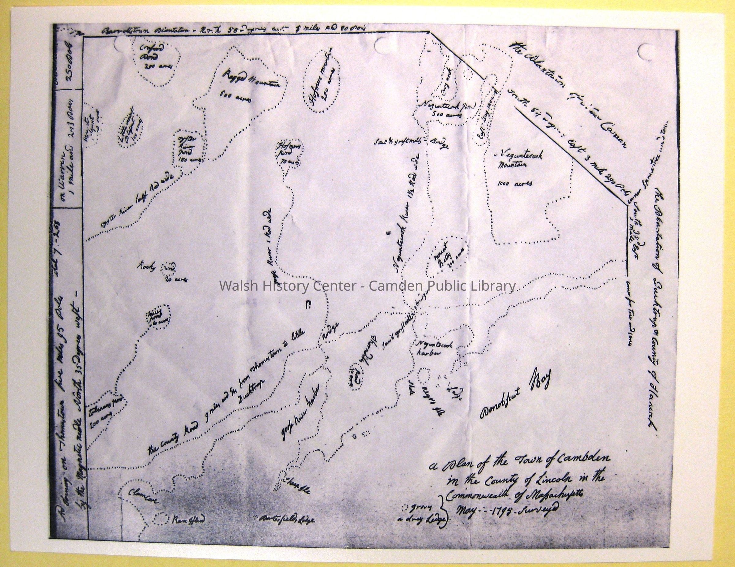
A PLAN OF THE TOWN OF CAMBDEN IN THE COUNTY OF LINCOLN IN THE COMMONWEALTH OF MASSACHUSETTS.
MAY 1795. SURVEYED. [Attributed to John Harkness, Surveyor, of Camden. The handwriting compares with his writing on the copy of his signed 1799 "MAP OF CAMBDEN."] It depicts boundaries, roads, water features, and mountains. This map appears to have been drafted in response to the Massachusetts General Court request to all Massachusetts towns for a surveyed map of the town. Those maps were gathered for use in drafting Osgood Carleton's map of Massachusetts and "MAP OF THE DISTRICT OF MAINE, MASSACHUSETTS," published in 1802. This image is a photocopy on heavy stock. The original is at the Camden-Rockport Historical Society.Collection
Camden Public Library Map CollectionCataloged By
Wyatt BerryAcquisition
Accession
WHC 2018.35Source or Donor
CPL Map CollectionAcquisition Method
Found in CollectionLexicon
Nomenclature 4.0
Nomenclature Secondary Object Term
MapNomenclature Primary Object Term
CartographNomenclature Sub-Class
Graphic DocumentsNomenclature Class
Documentary ObjectsNomenclature Category
Category 08: Communication ObjectsLOC Thesaurus for Graphic Materials
Maps, PlansSearch Terms
Camden, 1795, John Harkness, Cambden, SurveyLocation
Location
Cabinet
Map CaseBuilding
Walsh History CenterCategory
PermanentDate
October 21, 2025Category
PermanentMoved By
Wyatt BerryDate
September 21, 2018Inventory
Inventoried By
Wyatt BerryInventoried Date
Sep 21, 2018Relationships
Related Person or Organization
Person or Organization
John HarknessGeneral Notes
Note
Status: OK
Status By: Wyatt Berry
Status Date: 2018-09-21Created By
admin@catalogit.appCreate Date
September 13, 2018Updated By
admin@catalogit.appUpdate Date
October 26, 2025