Name/Title
CAMBDEN SEPTEMBER 20, 1799. PLAN OF CAMBDEN.Entry/Object ID
WHC 2018.36Description
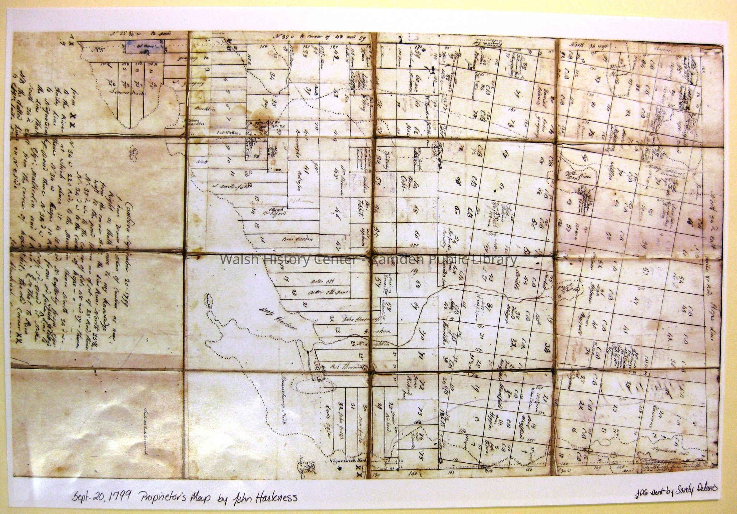
CAMBDEN SEPTEMBER 20, 1799. PLAN OF CAMBDEN. Drafted and signed by John Harkness, for the Twenty Associates of the Lincoln-shire Company, proprietors. Although drafted in 1799, eight years after the oceanfront and mountains of Canaan Plantation were added to the northeasterly side of the Town of Camden, this map shows just the portion
of lands in the original town controlled by those proprietors. The added portion was under control of General Henry Knox. This plan shows lots laid out in series 1-5 (Leverett's Neck) and series 1-75 in the surveys made for the 20 Associates under David Fales of Thomaston (Physician, Lawyer, and Surveyor in Thomaston). [There is a copy of the 20 Associates' directions to Fales through Ebenezer Thorndike in a letter. A copy of this
letter is in the Walsh History Center Collection. The original is among the Henry Augustus Peirce Papers in the archives of the New England Historic Genealogical Society. This map It also shows lots in series 1-95 laid out by Noah Miller, Surveyor, of Duck Trap Plantation for Charles Barrett, agent of the 20 Associates. On the lots in each series are the lot acreage and names of individual lot owners at the time of mapping. Initials "CB" indicate those lots under control of Charles Barrett. This map is a colour reproduction of the original in the Henry Augustus Peirce Collection of the New England Historic Genealogical Society. This copy was donated by Sanford Delano.Collection
Camden Public Library Map CollectionCataloged By
Wyatt BerryAcquisition
Accession
WHC 2018.36Source or Donor
CPL Map CollectionAcquisition Method
Found in CollectionLexicon
Nomenclature 4.0
Nomenclature Secondary Object Term
MapNomenclature Primary Object Term
CartographNomenclature Sub-Class
Graphic DocumentsNomenclature Class
Documentary ObjectsNomenclature Category
Category 08: Communication ObjectsLOC Thesaurus for Graphic Materials
Maps, PlansSearch Terms
1799, Cambden, John Harkness, Maps, SurveysLocation
Location
Cabinet
Map CaseBuilding
Walsh History CenterCategory
PermanentDate
October 21, 2025Category
PermanentMoved By
Wyatt BerryDate
September 21, 2018Inventory
Inventoried By
Wyatt BerryInventoried Date
Sep 21, 2018Relationships
Related Person or Organization
Person or Organization
John HarknessPerson or Organization
Charles BarrettGeneral Notes
Note
Status: OK
Status By: Wyatt Berry
Status Date: 2018-09-21Created By
admin@catalogit.appCreate Date
September 13, 2018Updated By
admin@catalogit.appUpdate Date
October 27, 2025