Name/Title
Map of CamdenEntry/Object ID
WHC 2010.32Scope and Content
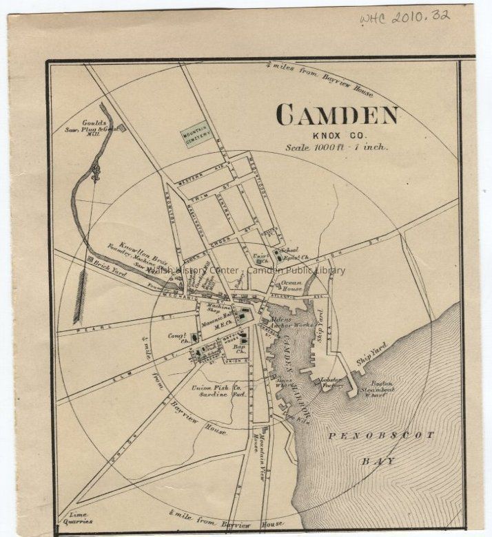
Map of Camden, Knox County, Maine removed from an 1887 Colby's Atlas of Maine. It is 1000 ft : 1 inch scale, and shows the Ocean House, Alden Anchor Works, Boston Steamboat wharf, Union Fish Co. sardine factory, lime quarries, shipyard, lobster factory, churches, Knowlton Brothers, schools, etc.Collection
Camden Public Library Map CollectionCataloged By
Heather BilodeauAcquisition
Accession
WHC 2010.32Source or Donor
ebayAcquisition Method
GiftLexicon
Nomenclature 4.0
Nomenclature Secondary Object Term
MapNomenclature Primary Object Term
CartographNomenclature Sub-Class
Graphic DocumentsNomenclature Class
Documentary ObjectsNomenclature Category
Category 08: Communication ObjectsLOC Thesaurus for Graphic Materials
MapsSearch Terms
Camden, MaineArchive Details
Creator
Colby's Atlas of Maine, 1887Date(s) of Creation
1887Location
Location
Container
WHC 2010.21/22/23/25 thru 30/32/34/35/36Shelf
Shelf 3Cabinet
Vault Shelving Unit 2Room
Storage RoomBuilding
Walsh History CenterCategory
PermanentDate
October 21, 2025Location
Room
Storage RoomBuilding
Walsh History CenterCategory
PermanentMoved By
Heather BilodeauDate
March 25, 2010Inventory
Inventoried By
Wyatt BerryInventoried Date
Mar 27, 2018Condition
Overall Condition
ExcellentDate Examined
Mar 25, 2010Examined By
Heather BilodeauGeneral Notes
Note
Notes: copy in map case; digital file on s:/maps
Status: OK
Status By: Heather Bilodeau
Status Date: 2010-03-25Created By
admin@catalogit.appCreate Date
March 25, 2010Updated By
admin@catalogit.appUpdate Date
October 26, 2025