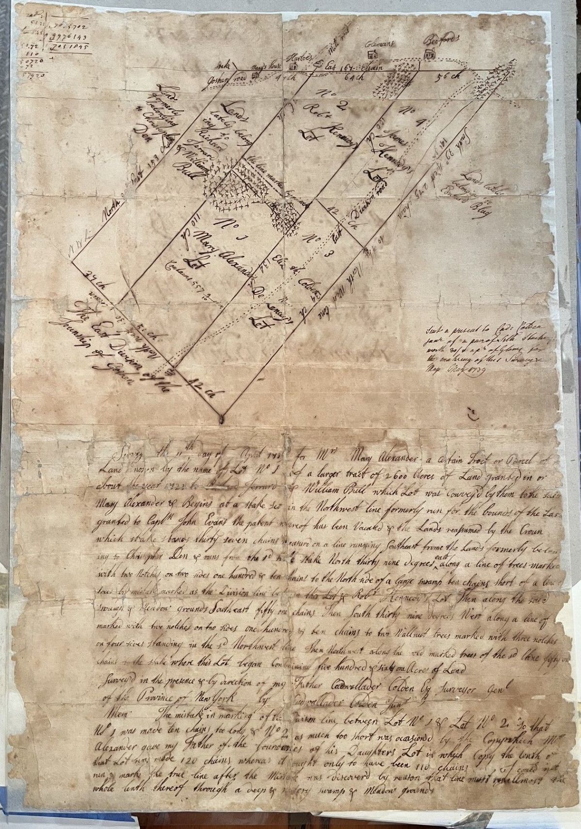
Map Annotations & Labels
(Top Math Annotations):
51.21
×
73
=
3738.33
51.21×73=3738.33
54.34
×
73
=
3966.82
54.34×73=3966.82
2705.15
2705.15
(Map Plots & Properties):
Top Boundary: Goshen road / Bull's House / Hutson's / Cat Kill / Mill brook / 6 chain / Chains / Bull's road / 56 ch
Upper Left Lots:
Land formerly belonging to Christopher Den / East 189 ch
Land lately belonging to Richard Surman & William Bull
Main Center Lots:
Nº 1 — Mary Alexander's Lot — Contains 567 [Acres] / South 39º East 110 ch / North 39º West 110 / East 42 ch
Nº 2 — Robt. Kennedy
Nº 3 — Elias Alsop / Division road
Nº 4 — James Kennedy's Lot / South 39º East 111 ch / North 39º West 111 ch
Right Boundary: Lands lately belonging to Ezekiel Bloomer
Bottom Left Boundary: NWK / 37 ch / 31 ch / The East Division of the Township of Goshen / South 39º East 111 ch / 42 ch
Right Side Note (Middle Margin):
"Sent a present to Capt. Catlin [?] part of a pair of White Stockings worth
25
/
6
25/6 as a present for the making of this Survey May 21st 1789"
Main Text Body
Survey'd the 11th day of April 1753 for Mrs. Mary Alexander a certain Tract or Parcel of Land known by the name of Lot Nº 1 of a larger tract of 2,600 Acres of Land granted in or about the year 1723 to Richard Surman & William Bull which Lot was conveyed by them to the said Mary Alexander & Begins at a stake set in the Northwest line formerly run for the bounds of the Land granted to Capt. John Evans the patent whereof has been Vacated & the Lands resumed by the Crown which stake stands thirty seven chains measured on a line running Southeast from the Lands formerly belonging to Christopher Den & runs from the sd stake North thirty nine degrees East along a line of trees marked with two notches on two sides one hundred & ten chains to the North side of a large swamp ten chains short of a line tree marked as the Division line between this Lot & Robt. Kennedy's Lot Then along the said swamp & Meadow grounds Southeast fifty six chains Then South thirty nine degrees West along a line of marked trees with two notches on two sides one hundred & ten chains to two Walnut trees marked with three notches on four sides standing in the sd Northwest line Then Northwest along the old marked trees of the sd line fifty six chains to the stake where this Lot began Containing five hundred & sixty seven Acres of Land.
Surveyed in the presence & by direction of my Father Cadwallader Colden Esq. Surveyor Genl. of the Province of New York by Cadwallader Colden Junr.
Memorandum (Bottom)
Mem. The mistake in marking of the division line between Lot Nº 1 & Lot Nº 2 so that Nº 1 was made ten chains too long & Nº 2 as much too short was occasioned by the Computation Mrs. Alexander gave my Father of the boundaries of her Daughter's Lot in which Copy the length of that Lot was made 120 chains whereas it ought only to have been 110 chains & I could not run & mark the true line after the Mistake was discovered by reason that line must run almost the whole length thereof through a deep & watery swamp & Meadow grounds.