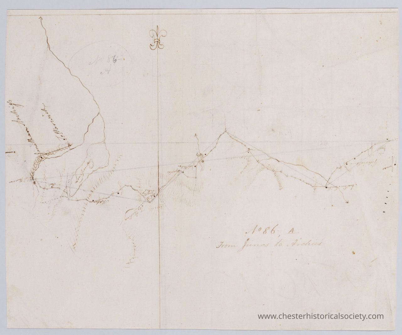
Map From Junes to Archies. No 86, A / by Robert Erskine F.R.S. Geogr. A. U.S. and Assistants.
From Junes to Archies. No 86 map.
The image depicts an old, hand-drawn map with faint lines and inscriptions, showing a long route with various curves and peaks, annotated with what appears to be a compass rose at the top, and faint legible text that indicates the map might be from the year 1779, describing a path "From Junea to Archies," set against a worn and slightly yellowing paper background, suggesting historical significance or possibly detailing an exploration or travel route from the past, with certain areas shaded to denote topographic features.
Name/Title
Map From Junes to Archies. No 86, A / by Robert Erskine F.R.S. Geogr. A. U.S. and Assistants.Entry/Object ID
chs-019514Secondary Title
Hand-drawn map by Robert Erskine F.R.S. Geogr. A. U.S. and Assistants with faint lines and inscriptions, showing a long route with various curves and peaks, annotated with what appears to be a compass rose at the top, and faint legible text that indicates the map might be from the year 1779, describing a path "From Junea to Archies,Description
From Junes to Archies. No 86, A / by Robert Erskine F.R.S. Geogr. A. U.S. and Assistants. In Collection(s) • Robert Erskine-Simeon DeWitt maps, 1778-1783 Descriptive Metadata Hide Details Creator / Contributor Erskine, Robert, 1735-1780 De Witt, Simeon, 1756-1834 De Witt, Richard Varrick United States. Continental Army. Surveying Dept. Title From Junes to Archies. No 86, A / by Robert Erskine F.R.S. Geogr. A. U.S. and Assistants. Road from Junes to Arches & Warwich - A. B & B2d. 86 From Junes to Arches & Warwich - A. B & B2d. 86 Index From June’s to Archer and Warwick Index From Junes to Archer & Warwich - A. B& B2 Alternative Title Road from Junes to Arches & Warwich - A. B & B2d. 86 From Junes to Arches & Warwich - A. B & B2d. 86 Index From June’s to Archer and Warwick Index From Junes to Archer & Warwich - A. B& B2 Date 1779 Physical Description 1 map : ms. ; 29 x 35 cm Series Rough draughts of surveys, begun A.D. 1778 ; 086, A Description In ink on verso: "es to Archie’s A," "No. 86. A," "86 a". In pencil on recto: "No 86-A" was originally written "No 84-A". Military topographic map. Covers the townships of Chester, Monroe and Woodbury in Orange County, New York. Shows roads running through Turners. Also shows buildings and owners’ names, landforms and streams. Pen-and-ink, pencil on laid paper. Shows relief by hachures. Soiled, stained and abraded. Mounted on cloth, bound and cropped, disbound and silked by subsequent owners. Cleaned after removal of backings 1999; some fill remains. Sheathed in mylar. Title proper from recto is the work of a later editor--Simeon DeWitt or his assign--subsequent to 1820. Index title, statement of responsibility, date, series title and series numbering by Erskine, but on separate index sheet filed at head of series. Watermark: "CC" beneath crown; the second C is reversed and interlocked with the first. No similar mark in Gravell and Miller. References: Guthorn, Peter J. American maps and map makers of the revolution, p. 17-22; Heusser, Albert H. George Washington’s map maker, p. 249-256. Scale Scale [ca. 1:34,000] Coordinates (W 74⁰15ʹ--W 74⁰07ʹ/N 41⁰20ʹ--N 41⁰17ʹ) Identifier Maps -- M30 M004505 n000146m Subject Buildings--New York (State)--Maps Landforms--New York (State)--Maps Landowners--New York (State)--Maps Rivers--New York (State)--Maps Roads--New York (State)--Maps Subject geographic name Hudson River Valley (N.Y. and N.J.)--History--18th century--Campaigns--Maps, Manuscript Orange County (N.Y.)--History--18th century--Campaigns--Maps, Manuscript Material type or medium of original manuscript maps Rights This digital image may be used for educational or scholarly purposes without restriction. Commercial and other uses of the item are prohibited without prior written permission from the New-York Historical Society. For more information, please visit the New-York Historical Society's Rights and Reproductions Department web page at http://www.nyhistory.org/about/rights-reproductionsCollection
New-York Historical SocietyCategory
War, Revolutionary 1775-1783