Name/Title
"LIEUT. WHEELER'S EXPEDITION: CALIFORNIA, NEVADA, ARIZONA, 1875"Entry/Object ID
2004.178.1.1Description
"LIEUT. WHEELER'S EXPEDITION: CALIFORNIA, NEVADA, ARIZONA, 1875"
Color: Black; Blue; Green; Red; White
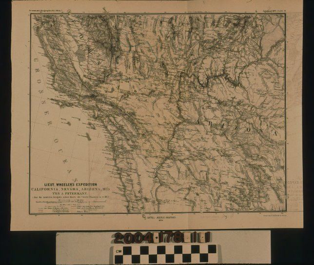
"Lieut. Wheeler's Expedition: California, Nevada, Arizona, 1875," a map published by Justus Perthes, Gothenborg, Germany, 1876. The map shows southern California and Nevada, and most of Arizona as related to the military expedition of G. U. Wheeler and his compatriots. Each division of the expedition has its routes indicated in varius colors, but the full range of the expedition was from Big Pine to the north in California to the Amargosa Desert and the Colorado River areas of southern Nevada and western Arizona on the east, to the present Salton Sea on the south, and the Los Angeles and Ventura area on the west. General features relating to place names, mountain ranges, bodies of water and water courses, elevations, and other aspects are shown. Of interest, among the several California missions, is the "Mission Craneras" shown on the Rancho La Puente. At the bottom left is the title, legend showing the colors for the several divisions of the expedition, a scale of kilometers, and other information. In good condition, the item has creases and the left edge, some yellowing and browning along the edges, and original vertical fold, ink bleeding or transfer of the image at the right three-quarters, pin holes at the left from removal, and light handling stains, especially along the edges.Lexicon
Search Terms
Two-dimensional, Maps, Justus Perthes [firm], West (U. S.)--Discovery and exploration