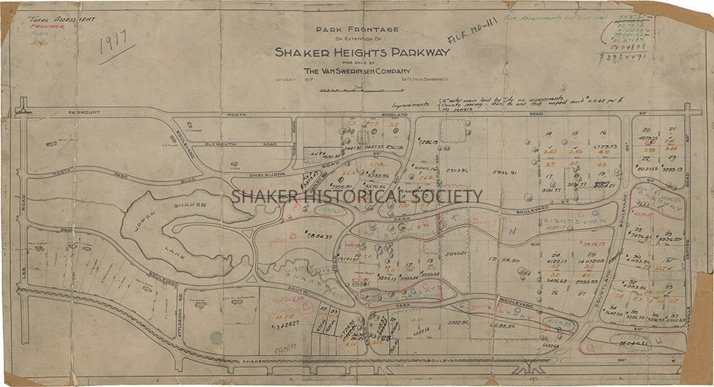
Park Frontage On Extension of Shaker Heights Parkway, 1917
Name/Title
Park Frontage On Extension of Shaker Heights Parkway, 1917Entry/Object ID
4.1.10Tags
1910s, 20th Century, Cleveland Heights, Boulevard Neighborhood, Malvern Neighborhood, Shaker Heights, Van Sweringens, Shaker LakesDescription
Real estate subdivision map for Shaker Heights and Cleveland Heights Village parkway frontages by the F. A. Pease Engineering Co. for The Van Sweringen Co. The area shown is bounded by Lee Road to the west, Fairmount Boulevard/North Woodland Road to the north, Warrensville Center Road to the west, and Shaker Boulevard to the south. Lots above and below Upper Lake (Horseshoe Lake) are printed with remaining lots handwritten in pen and pencil. The key identifies total assessment (black), frontage (pink), park (green), and area (organge). Cleveland Heights land owners listed include Kenyon V. Painter, Clifford W. Fuller, Phillip P. Nungesser, and Arthur H. Otis. Shaker Heights land owners listed included Fred C. Chandler, Laura H. Caine, Ford M. Clapp, Louis E. Myers, Clara N. Fritzsche, W. D. B. Alexander, Katharine L. Perry, Mary S. Ranney, Alfred L. Fritzsche, Frank A. Arter, and O. P. and M. J. Van Sweringen.Collection
Map CollectionCategory
Maps
Archives